Unlike the critical forest fire situation in British Columbia, this has the best year in recent memory for forest fires in Manitoba. Two words provide the explanation this summer: cool and wet.
As of earlier this week, there had been 130 fires across Manitoba this fire season, consuming approximately 2,437 hectares. Humans caused approximately 77 fires and lightning caused 53.
There have been have been far fewer fires than in the years Manitoba has had major fires. In 1989, the province 1,226 fires that damaged 3,567,947 hectares. In 2003, there were 1,226 fires that destroyed 918,845 hectares.
So far 80 firefighters been sent from Manitoba to British Columbia with the deployment co-ordinated by the Canadian Interagency Forest Fire Centre in Winnipeg.
In addition to the 80 firefighters, 25 pumps and relay tanks are being shipped to British Columbia. The first group of 40 firefighters went July 25 along with 50 pumps.
The cool, wet summer has also meant wild land firefighters here have had a chance to hone their skills with lots of practice drills, as well as work on brushing and other park maintenance.
Paint Lake-based wild land firefighters have been busy brushing this summer much of the rigorous 22-kilometre return hiking trail between Pisew Falls and Kwasitchewan Falls along the Grass River.
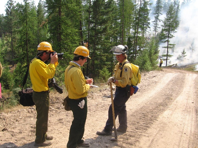
Bryan Stefaniuk, who is Conservation Manitoba's district supervisor for the Snow Lake District said the Wekusko Fire base has four initial attack crews (each crew has five members) and two Helitac officers at the ready. A contract Bell 205 helicopter with a pilot and engineer is also positioned at Wekusko for the summer months.
Stefaniuk said that in order for the Wekusko Base to be functional, a number of support staff are also required. "We have a kitchen facility staffed by three cooks," he explained. "Grounds maintenance is handled by one labourer/operator and one green team person. We have one district fire ranger in charge of equipment caches/inventories, and we have one radio operator in town for communication support. This does not include the NROs, or regular time clerk."
The Northwest Region encompasses the area from the Churchill River in the north, the Saskatchewan border in the west, Easterville Road to the south, and Lake Winnipeg/Ponton to the east. "The Snow Lake Fire Base provides regional coverage and is not limited to just the Snow Lake area," said Stefaniuk.
Regardless whether there are fires in the area or not, the crews keep themselves busy. "Our staff is quite self motivated in terms of staying physically fit," says Stefaniuk. "People may notice them out jogging or in the gym, working out on their own time. It is not a stretch to find someone in the gym at 6 a.m."
Each initial attack crewmember is required to pass a standard fire program physical fitness test before they are offered employment. "They are also required to pass an arduous pack test in order to be exported out of Manitoba should the need arise," he added. "Due to the physical nature of the job; we allocate one hour a day for fitness. A variety of activities are involved."
Of these, team sports such as the basketball are intended to sustain good physical conditioning and build on a team concept. The Wekusko Base - or Tac Camp as it is referred to locally - has a fairly good gym with some recent purchases of weight training equipment and exercise machines. Stefaniuk says that this provides for a variety of physical activities
"People may have also noticed that we have two female crewmembers this year. They are required to pass the same tests as the male crewmembers and in many cases they surpass their counterparts. The girls are excellent workers. They are a pretty good crew in all."
On Aug. 1, an initial attack (IA) fire crew of wild land firefighters aboard a Bell 205 Ultra helicopter from the Paint Lake Helitac Base deplaned on a rock peninsula near Coffee Cove Trail Head on the beach at Paint Lake Provincial Park to demonstrate their skills.
Following the deplaning, the helicopter dropped bucket loads of water with the Bambi bucket on a campfire and smoke bombs as part of the firefighting demonstration. The Bambi bucket holds 300 gallons of water - the equivalent of a back yard swimming pool.
The first water bucket is believed to have been developed by Jim Grady of Okanagan Helicopters, working with Henry Stevenson, who owned a machine shop in Nelson, B.C. Development began in the mid-1950s and the "Monsoon Bucket" was operational in 1962. The bucket was a converted 45-gallon drum with a trap door in the bottom that was activated by the pilot in flight.
The major initial attack bases in Manitoba are Bissett in the Eastern Region, Snow Lake in the Northwest Region and Paint Lake in the Northeast Region.
Trinette Konge, senior park interpreter for Manitoba Conservation, Northeast Region at Paint Lake Provincial Park, said, "It costs at least $10,000 to bring one Helitac crew to a forest fire, those costs escalate quickly in the event of a water bomber or larger fire which would require several crews.
"A tanker (water bomber plane) costs over $10,000 an hour. A person, if they are found to be responsible for starting the fire could be charged the cost of suppressing it."
Helitac denotes "helicopter-delivered fire resources" and is the system of managing and utilizing choppers and their crews to attack wildfires as a first-spear firefighting assault.
Because of the manouverability of helicopters, Helitac teams can deplane or rappel if necessary near a forest fire and penetrate and control areas unreachable by ground crews.
The term Helitac is believed to have first appeared in print in a June 10, 1956 Los Angeles Times article, "Fire-Fighting Copter Tests Start in Forest," on Page A23, "which described the "first of a series of tests-tabbed the Helitac Program-on the use of helicopters in firefighting will start next week in the San Bernardino National Forest."
Manitoba has established a stand-by system for all aircraft contracted for forest fire protection missions. This consists of five levels of readiness, depending on the fire forecast and the time of day:
* Red Alert: Crews are at the base with the aircraft serviced, fuelled and ready for immediate dispatch;
* Yellow Alert: Crews can be contacted and be at the base within 15 minutes. The aircraft is fuelled. Minor aircraft servicing is permitted. The aircraft must be airborne within 30 minutes of receiving the dispatch call;
* Blue 1: The crews can be contacted and the aircraft can be airborne within one hour of receiving a dispatch call. Routine servicing and maintenance of the aircraft are permitted;
* Blue 2: The crews can be contacted and the aircraft airborne within two hours of receiving a dispatch call. Routine servicing and maintenance of the aircraft are permitted;
* Green Stand-down.
The provincial Conservation Fire Program is responsible for the detection and suppression of wild fires in Manitoba. The program manages all human and equipment resources needed for fighting wild fires in the province. Staff monitors weather patterns, lightning strikes, soil moisture and forest conditions to determine the probability and location of wild fires. Manitoba's Fire Program works in close co-operation with other forest firefighting agencies and jurisdictions. Equipment and other resources are shared through the Canadian Interagency Forest Fire Centre.
Manitoba's forest fire program uses early fire detection technology and lightning strike satellite tracking, air patrols and calls to the fire reporting line. Open fires are prohibited from April 1 to Nov. 15 annually except under a burning permit or in approved fire pits such as campfire pits in provincial campsites.
Some years are dramatically mixed for Manitoba, as was the case in the summer of 2007. Hot, dry weather throughout Northern Manitoba in July combined with only "spotty" rain and lots of lightning strikes igniting the summer forest fire season, said Gary Friesen, the provincial duty fire control officer in Winnipeg with Manitoba Conservation's fire program.
"The lightning is the key, because without that we would not be experiencing these fires," he said at the time two years ago. Overall of the 260 forest fires reported in Manitoba as of July 25, 2007, human causes were responsible for 173 and lightning had sparked 87. The 260 fires reported to date as of July 25 2007 compared to an average of 354 as of late July, Friesen said.
The Tadoule Lake fire in July 2007 forced the military evacuation of about 350 members of the Sayisi Dene Nation.
Before dawn, a search and rescue Hercules aircraft was dispatched from 17 Wing at CFB Winnipeg to the community because there's no road out of the remote area. The Hercules flew people to Churchill, and from there evacuees were flown to Brandon and Winnipeg.
The rescue operation involved several federal agencies in addition to the Department National Defence, including Indian and Northern Affairs and Public Safety Canada.
The first community to see evacuations in Northern Manitoba in July 2007 was the O-Pipon-Na-Piwin Cree Nation at South Indian Lake. More than 360 residents were flown to Winnipeg over a three-day period. The Manitoba Association of Native Fire Fighters (MANFF), an aboriginal volunteer group, which is the emergency management entity for the Assembly of Manitoba Chiefs, worked to co-ordinate the removal operations.
The South Indian Lake fire, at about 77,000 hectares in size, was the largest of the forest fires burning that July and was located about 18 kilometres directly south of South Indian Lake and about 62 kilometres northwest of Thompson. Firefighters were able to establish a "secure anchor point" on the edge of the fire and hold the line at the Rat River, Friesen said.
Another 150 people from Shamattawa, about 850 kilometres east of Thompson, were placed on evacuation alert two years ago, also because of smoke conditions.Twenty-five firefighters from five crews in British Columbia were brought into to aid the 480 firefighters from Manitoba battling the wilderness blazes. An equal number from Ontario followed.
Two Canadair CL-215 water bombers from Buffalo Airways in the Northwest Territories, the first aircraft ever designed specifically for water bombing by 'scooping' 5,443 kilograms of water into the internal tanks within 10 seconds from a lake as close to the forest fire as possible, joined the seven-plane Manitoba water bomber fleet in fighting the fires, along with 20 helicopters. Two aerial water tankers were also used.
The last major forest fires in 2007 in Northern Manitoba were the 16,000-hectares Hughes Lake fire, about 11 kilometres east of Lynn Lake, which at one point threatened a Manitoba Telecom Services (MTS) communications tower in the vicinity, and Fire 16, also known as the Baril Lake Fire or William Lake Fire, More than 200 firefighters and heavy equipment were sent to Baril Lake, 120 kilometres east of The Pas and 70 kilometres north of Grand Rapids, where the fire was estimated at 4,000 hectares.
The massive resources were poured into the fire because it threatened standing timber on land licensed to Tolko Industries Ltd., of Vernon, B.C. for cutting and at one point was virtually on top of roadside timber piles.
Tom Mirus, manager of fire and environmental emergency response programs in for Manitoba Conservation's Fire Program, said the strategy in fighting forest fires "is to surround and drown" moving ever inward toward the centre of the fire from "the edges."
With generally much cooler, wetter weather prevailing across Manitoba in August 2007, compared to a scorching, sunny July, the forest fire situation and risk abated to the point the province was able to loan 42 firefighters to Montana to battle the 40,000-hectare Chippy Creek Wildland Fire, near Kalispell and the Flathead Reservation in the northwest corner of the state.
Manitoba officials said their forest fire season at home usually winds down by mid-August. The Manitoba crews, used to more water, fewer roads and smaller hills than are found in Montana, were using hand tools and chainsaws to clear vegetation at Chippy Creek.
"I love this country, the scenery is gorgeous," Manitoba crew boss Keith Yarnell said from the line on Division L of the Chippy Creek fire Aug. 24, 2007. "You get to travel, see another part of the world and meet a lot of people, and everyone seems so friendly here."
The Chippy Creek fire was a totally different type of landscape than Manitoba fire crews were used to working in at home. Compared to similar areas in the United States, Northern Manitoba resembles Minnesota more than anything else, complete with numerous lakes, peat bogs and otherwise generally flat topography.
In contrast, the portion of northwest Montana that the Manitobans were working in featured heavily timbered mountains, steep slopes and rocky ridges.
The Chippy Creek Wildland Fire was the largest forest fire to burn in northwest Montana since the 41,200-hectare 1929 Half Moon Fire erupted just west of Columbia Falls, burning east over Teakettle Mountain and into Glacier National Park's Apgar Village and the nearby Belton Hills. The fire's perimeter stretched over 37 kilometres.
The fire burned in steep, rugged country, with continuous timber and dead and downed lodgepole pine, about 67 kilometres southwest of Kalispell and 39 kilometres north of Thompson Falls, Mont. The "terrain difficulty" was rated as "extreme" according to the Northern Rockies Interagency Incident Management Team in Missoula. Mont.
In addition to the different terrain, fire is fought differently in the two countries. In Northern Manitoba, crews rely heavily on helicopters to access fires in areas mostly without roads. Once they're on the line, they then utilize fireline water shows, using pumps and hose-lays from nearby lakes, to suppress their fires.
The Canadian firefighters usually work fires in small crews of four or five, basically bivouacking on site until the fire is totally out. The concept of 20-firefighter crews working out of large, organized fire camps, like they were on the Chippy Creek fire, was largely foreign to them.
While the worst of last year's Northern Manitoba forest fire season was over by early June, it didn't look that way in late May of last year, which appeared to signal a bad forest fire season for Northern Manitoba with about 1,700 residents of Sherridon, Norway House, St. Theresa Point, Wasagamack, Mission Island and Fort Island ordered evacuated because of forest fire danger.
At Sherridon, south of Pukatawagan, the fire burned right to the townsite. The mayor and council of Sherridon ordered a full evacuation due to concerns over the single road becoming impassable. There are about 500 residents in the Sherridon area, but only 51 residents obeyed an evacuation order for 150 of them, as the only road in an out of the community was threatened by fire, and left for The Pas.
The rest stayed behind and risked their safety to successfully save their homes. Along with Manitoba Conservation firefighting crews and staff from the Office of Fire Commissioner, the residents who stayed behind equipped roofs with a sprinkler system, spraying a light drizzle of water from Kississing Lake on the entire town, saving it from a bombardment of fire sparks that lasted for days as a wall of flame bore down on the community.
Manitoba officials said they believe this is the first time an entire town has been saved by an artificial drizzle.
Pukatawagan to the north, however, was cut off from rail service after a wooden railway bridge over a small creek between Sherridon and Cranberry Portage was destroyed in the blaze.
Pukatawagan is home to the Mathias Colomb Cree Nation and is located about 170 kilometres west of Thompson and about 30 kilometres east of the Saskatchewan border. The population of the Mathias Colomb Cree Nation is about 2,500 people and there are another 1,950 people in Pukatawagan, the local RCMP detachment said. The Mathias Colomb Cree Nation declared a state of emergency as supplies of food and other basic necessities dwindle, although there is still more costly air access available to the community. Fuel was only being allowed for emergency vehicles.
Via Rail Canada runs a train twice a week on the 200-kilometre stretch of line between The Pas and Pukatawagan, under an agreement with Keewatin Railway Co., a firm owned by a First Nations consortium. KRC owns and maintains the track. Many Pukatawagan residents customarily take the train to The Pas once a month to get food and other items.
About 80 feet of track across the creek needed rebuilding. Hudson Bay Railway Company, in conjunction with the rail line owner, Keewatin Railway Company, assembled the materials and crew required to reconstruct the bridge and restore service to Pukatawagan.
The Health Canada hospital in Norway House was also evacuated and patients were transported to Cross Lake.
Various fire attributes are modeled with the Canadian Forest Fire Weather Index System and Forest Fire Behaviour Prediction System developed by the Canadian Forest Service. Fire weather indices are modeled on the basis of weather station data and include ratings for fine fuel moisture, duff moisture, drought, initial spread, build up and fire weather. The Forest Fire Behaviour Prediction System uses information on fire weather, fuel type, topography, and foliar moisture content to predict the rate of spread, fire intensity, type of fire, and fuel consumption.
The Canadian Forest Fire Weather Index System consists of six components that account for the effects of fuel moisture and wind on fire behaviour. The Canadian Forest Fire Behaviour Prediction System provides quantitative estimates of potential head fire spread rate, fuel consumption, and fire intensity, as well as fire descriptions. With the aid of an elliptical fire growth model, it gives estimates of fire area, perimeter, perimeter growth rate, and flank and backfire behaviour.
The first three components, the fuel moisture codes, are numeric ratings of the moisture content of litter and other fine fuels, the average moisture content of loosely compacted organic layers of moderate depth, and the average moisture content of deep, compact organic layers.
The remaining three components are fire behaviour indices, which represent the rate of fire spread, the fuel available for combustion, and the frontal fire intensity; their values rise as the fire danger increases.
- with a file from Marc Jackson


